
Geospatial data analytics lets you use location data (latitude and longitude) to get business insights. It’s used for a wide variety of applications in industry, such as package delivery logistics services, ride-sharing services, autonomous control of vehicles, real estate analytics, and weather mapping.
ST_IsClosed and ST_IsRing.
From our partners:
BigQuery geospatial functions
In BigQuery, you can use the GEOGRAPHY data type to represent geospatial objects like points, lines, and polygons on the Earth’s surface. In BigQuery, geographies are based on the Google S2 Library, which uses Hilbert space-filling curves to perform spatial indexing to make the queries run efficiently. BigQuery comes with a set of geography functions that let you process spatial data using standard ANSI-compliant SQL. (If you’re new to using BigQuery geospatial analytics, start with Get started with geospatial analytics, a tutorial that uses BigQuery to analyze and visualize the popular NYC Bikes Trip dataset.)
The new ST_IsClosed and ST_IsRing functions are boolean accessor functions that help determine whether a geographical object (a point, a line, a polygon, or a collection of these objects) is closed or is a ring. Both of these functions accept a GEOGRAPHY column as input and return a boolean value.
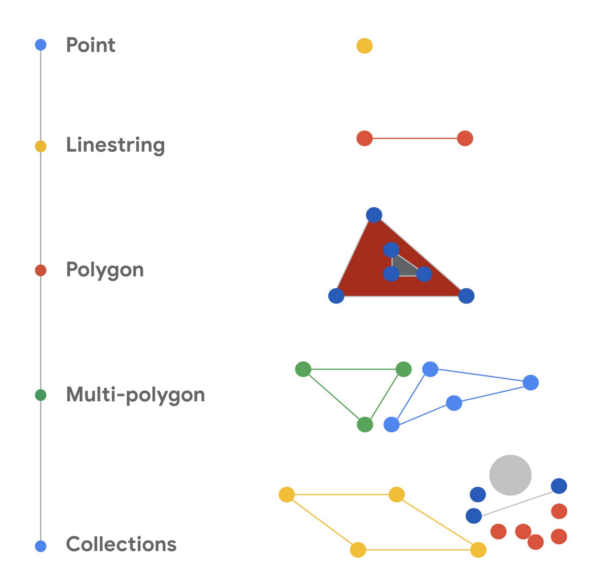
The following diagram provides a visual summary of the types of geometric objects.
Is the object closed? (ST_IsClosed)
The ST_IsClosed function examines a GEOGRAPHY object and determines whether each of the elements of the object has an empty boundary. The boundary for each element is defined formally in the ST_Boundary function. The following rules are used to determine whether a GEOGRAPHY object is closed:
- A point is always closed.
- A linestring is closed if the start point and end point of the linestring are the same.
- A polygon is closed only if it’s a full polygon.
- A collection is closed if every element in the collection is closed.
- An empty GEOGRAPHY object is not closed.
Is the object a ring? (ST_IsRing)
The other new BigQuery geography function is ST_IsRing. This function determines whether a GEOGRAPHY object is a linestring and whether the linestring is both closed and simple. A linestring is considered closed as defined by the ST_IsClosed function. The linestring is considered simple if it doesn’t pass through the same point twice, with one exception: if the start point and end point are the same, the linestring forms a ring. In that case, the linestring is considered simple.
Seeing the new functions in action
The following query shows you what the ST_IsClosed and ST_IsRing function return for a variety of geometric objects. The query creates a series of ad-hoc geography objects and uses the UNION ALL statement to create a set of inputs. The query then calls the ST_IsClosed and ST_IsRing functions to determine whether each of the inputs are closed or are rings. You can run this query in the BigQuery SQL workspace page in the Google Cloud console.
WITH example AS(
 SELECT ST_GeogFromText('POINT(1 2)') AS geography
 UNION ALL
 SELECT ST_GeogFromText('LINESTRING(2 2, 4 2, 4 4, 2 4, 2 2)') AS geography
 UNION ALL
 SELECT ST_GeogFromText('LINESTRING(1 2, 4 2, 4 4)') AS geography
 UNION ALL
 SELECT ST_GeogFromText('POLYGON((0 0, 2 2, 4 2, 4 4, 0 0))') AS geography
 UNION ALL
 SELECT ST_GeogFromText('MULTIPOINT(5 0, 8 8, 9 6)') AS geography
 UNION ALL
 SELECT ST_GeogFromText('MULTILINESTRING((0 0, 2 0, 2 2, 0 0), (4 4, 7 4, 7 7, 4 4))') AS geography
 UNION ALL
 SELECT ST_GeogFromText('GEOMETRYCOLLECTION EMPTY') AS geography
 UNION ALL
 SELECT ST_GeogFromText('GEOMETRYCOLLECTION(POINT(1 2), LINESTRING(2 2, 4 2, 4 4, 2 4, 2 2))') AS geography)
SELECT
 geography,
 ST_IsClosed(geography) AS is_closed,
 ST_IsRing(geography) AS is_ring
FROM example;
is_closed and is_ring columns what each function returns for the various input geography objects. 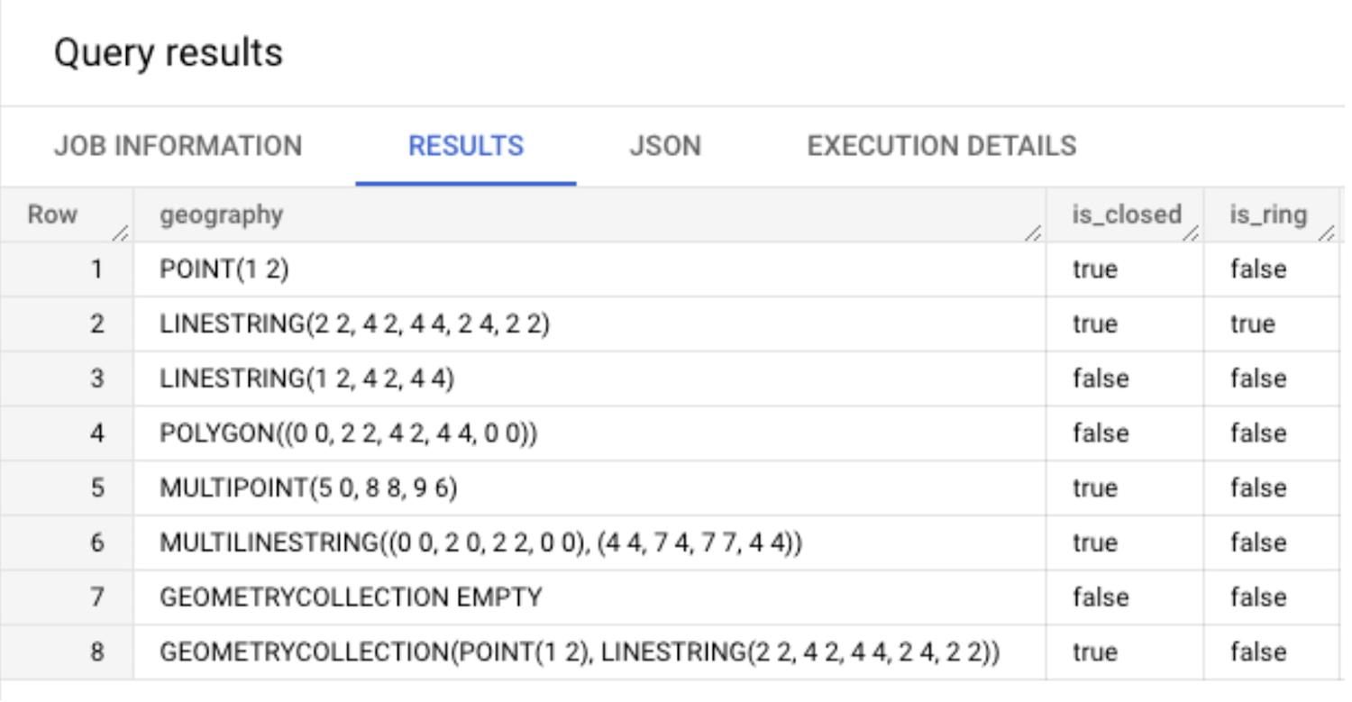
The new functions with real-world geography objects
In this section, we show queries using linestring objects that represent line segments that connect some of the cities in Europe. We show the various geography objects on maps and then discuss the results that you get when you call ST_IsClosed and ST_IsRing for these geography objects.
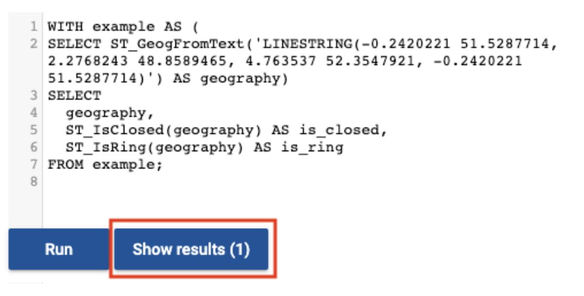
You can run the queries by using the BigQuery Geo Viz tool. The maps are the output of the tool. In the tool you can click the Show results button to see the values that the functions return for the query.
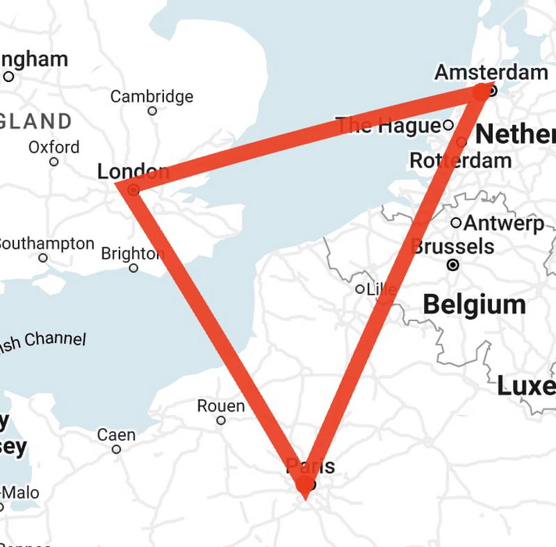
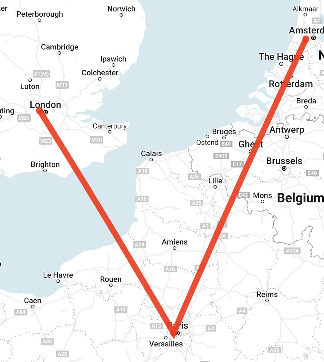
Start point and end point are the same, no intersection
In the first example, the query creates a linestring object that has three segments. The segments are defined by using four sets of coordinates: the longitude and latitude for London, Paris, Amsterdam, and then London again, as shown in the following map created by the Geo Viz tool:
WITH example AS (
SELECT ST_GeogFromText('LINESTRING(-0.2420221 51.5287714, 2.2768243 48.8589465, 4.763537 52.3547921, -0.2420221 51.5287714)') AS geography)
SELECT
  geography,
  ST_IsClosed(geography) AS is_closed,
  ST_IsRing(geography) AS is_ring
FROM example;
ST_IsClosedreturnstrue. The start point and end point of the linestring are the same.ST_IsRingreturnstrue. The geography is closed, and it’s also simple because there are no self-intersections.
Start point and end point are different, no intersection
Another scenario is when the start and end points are different. For example, imagine two segments that connect London to Paris and then Paris to Amsterdam, as in this map:
WITH example AS (
SELECT ST_GeogFromText('LINESTRING(-0.2420221 51.5287714, 2.2768243 48.8589465, 4.763537 52.3547921)') AS geography)
SELECT
  geography,
  ST_IsClosed(geography) AS is_closed,
  ST_IsRing(geography) AS is_ring
FROM example;
ST_IsClosed and ST_IsRing functions return the following values:
ST_IsClosedreturnsfalse. The start point and end point of the linestring are different.ST_IsRingreturnsfalse. The linestring is not closed. It’s simple because there are no self-intersections, butST_IsRingreturnstrueonly when the geometry is both closed and simple.
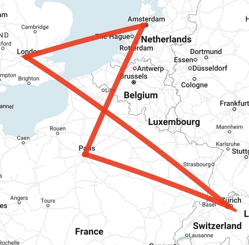
Start point and end point are the same, with intersection
The third example is a query that creates a more complex geography. In the linestring, the start point and end point are the same. However, unlike the earlier example, the line segments of the linestring intersect. A map of the segments shows connections that go from London to Zürich, then to Paris, then to Amsterdam, and finally back to London:
WITH example AS (
SELECT ST_GeogFromText('LINESTRING(-0.2420221 51.5287714, 8.393389 47.3774686, 2.2768243 48.8589465, 4.763537 52.3547921, -0.2420221 51.5287714)') AS geography)
SELECT
  geography,
  ST_IsClosed(geography) AS is_closed,
  ST_IsRing(geography) as is_ring
FROM example;
ST_IsClosed and ST_IsRing return the following values:
ST_IsClosedreturnstrue. The start point and end point are the same, and the linestring is closed despite the self-intersection.ST_IsRingreturnsfalse. The linestring is closed, but it’s not simple because of the intersection.
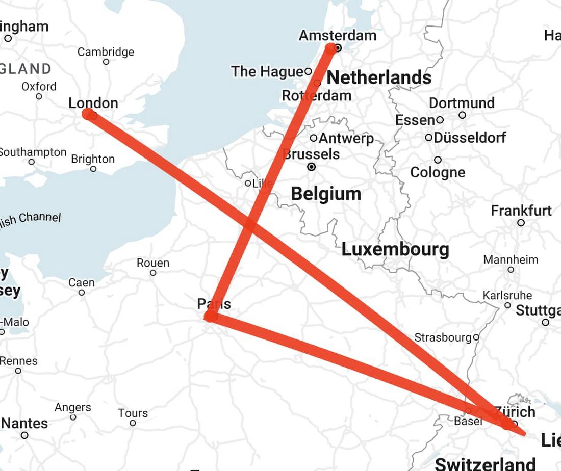
Start point and end point are different, with intersection
In the last example, the query creates a linestring that has three segments that connect four points: London, Zürich, Paris, and Amsterdam. On a map, the segments look like the following:
WITH example AS (
SELECT ST_GeogFromText('LINESTRING(-0.2420221 51.5287714, 8.393389 47.3774686, 2.2768243 48.8589465, 4.763537 52.3547921)') AS geography)
SELECT
  geography,
  ST_IsClosed(geography) AS is_closed,
  ST_IsRing(geography) AS is_ring
FROM example;
ST_IsClosedreturnsfalse. The start point and end point are not the same.ST_IsRingreturnsfalse. The linestring is not closed and it’s not simple.
Try it yourself
Now that you’ve got an idea of what you can do with the new ST_IsClosed and ST_IsRing functions, you can explore more on your own. For details about the individual functions, read the ST_IsClosed and ST_IsRing entries in the BigQuery documentation. To learn more about the rest of the geography functions available in BigQuery Geospatial, take a look at the BigQuery geography functions page.
Thanks to Chad Jennings, Eric Engle and Jing Jing Long for their valuable support to add more functions to BigQuery Geospatial. Thank you Mike Pope for helping review this article.
By: Kannappan Sirchabesan (Data Engineer) and Michael Entin (Software Engineer)
Source: Google Cloud Blog
For enquiries, product placements, sponsorships, and collaborations, connect with us at [email protected]. We'd love to hear from you!
Our humans need coffee too! Your support is highly appreciated, thank you!