While there has been a lot of attention given to wildfires, floods, and hurricanes, heat-related weather events are still understudied and underreported. Every summer, heat waves pose a major threat to the health of people and ecosystems. 83% of the North American population lives in cities, where the urban heat island (UHI) effect leads to higher local temperatures compared to surrounding rural areas.
But not everyone living in US cities experiences summer heat waves and urban heat islands equally. Communities with lower incomes or people of color are more likely to be impacted by extreme heat events, both due to fewer green spaces in urban areas and not having access to air conditioning. While there have been many studies that have shed light on environmental inequities between neighborhoods of varying income levels, there has been little analysis of what it will take to provide all people with protection from severe heat.
From our partners:
In the summer of 2019, TC Chakraborty, then a PhD candidate at the Yale School of the Environment, and Tanushree Biswas, then Spatial Data Scientist at The Nature Conservancy, California, met at one of our Geo for Good Summits. The summits bring together policymakers, scientists, and other change-makers who use Google’s mapping tools. They wanted to share ideas in their areas of expertise (urban heat and tree cover, respectively) and explore a potential path to address urban climate change inequities using open tools and a suite of datasets. Given the ability of tree cover to help mitigate local heat in cities, they wondered how much space is actually available for trees in lower income urban neighborhoods.
If this available space were to be quantified, it would provide estimates of several co-benefits of tree cover beyond heat mitigation, from carbon sequestration to air pollution reduction, to decreased energy demand for cooling, to possible health benefits. Chakraborty and Biswas believed that increasing the tree canopy in this available space could provide economic opportunities for green jobs as well as more equitable climate solutions. Inspired by this shared vision, they joined forces to explore the feasibility of adding trees to California’s cities.
Three years later, in June 2022, Chakraborty, Biswas, and co-authors L.S. Campbell, B. Franklin, S.S. Parker, and M. Tukman published a paper to address this challenge. The study combines medium-to-high-resolution satellite observations with census data to calculate the feasible area available for urban afforestation — planting new trees — for over 200 urban clusters in California. The paper demonstrates a systematic approach that leverages publicly available data on Google Earth Engine, Google’s planetary-scale platform for Earth science data & analysis, which is free of charge for nonprofits, academics, and research use cases. Results from the study can be explored through a Earth Engine web application: Closing Urban Tree Cover Inequity (CUTI).
California is the most populated state in the United States, the fifth largest economy in the world and frequently impacted by heat waves. This makes California a prime location to demonstrate approaches to strategically reducing surface UHI (SUHI), which has the potential to positively impact millions, especially those vulnerable to heat risk. Chakraborty et al. (2022) found that underprivileged neighborhoods in California have 5.9% less tree cover (see Fig. 1 for an illustrative example for Sacramento) and 1.7 °C higher summer SUHI intensity than more affluent neighborhoods. This disparity in tree cover can be partially closed through targeted urban afforestation.
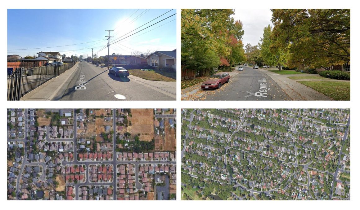
Fig 1. Street and satellite views of an underprivileged and a more affluent neighborhood in Sacramento.
Leveraging the wealth of data for cities in California, including heat-related mortality and morbidity data, sensitivity of residential energy demand to temperature, and carbon sequestration rates of California’s forests, the researchers calculated co-benefits of several urban afforestation scenarios. For their maximum possible afforestation scenario, they found potential for an additional 36 million (1.28 million acres of) trees, which can provide economic co-benefits, estimated to be worth as much as $1.1 billion annually:
- 4.5 million metric tons of annual CO2 sequestration
- Reduction in heat-related medical visits (~4000 over 10 years)
- Energy usage and cost reductions
- Stormwater runoff reduction
- Property value increase
With a focus on reducing disparities in SUHI and tree cover within these cities, the study provides suitability scores for scaling urban afforestation at the census-block group level across California. By focusing on California neighborhoods with high suitability scores, the authors estimate that an annual investment of $467 million in urban afforestation would both reduce heat disparities and generate $712 million of net annual benefits. Specifically, these benefits would go to 89% of the approximately 9 million residents in the lowest income quartiles of California cities. This annual investment equates to a 20-year commitment of $9.34 billion or 10,000 Electric Vehicles annually.
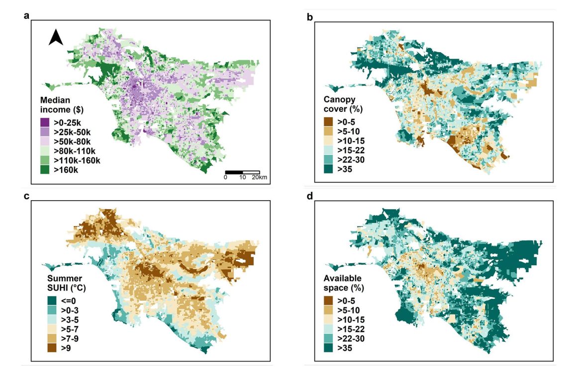
Fig. 2 Maps showing a median income, b current canopy cover percentage, c summer daytime surface urban heat island (SUHI) intensity, and d available area for planting trees as percentage of total area for census block groups in the Los Angeles urban cluster (Image source: TC Chakraborty and Tanushree Biswas).
The adverse effects of climate change disproportionately impact cities, so it’s critical to start thinking about viable solutions to address environmental disparities within urban communities. Providing urban planners with data-driven tools to design climate-resilient cities is a key first step. The Chakraborty et al. study leverages Earth Engine data, tech, and cloud compute resources to provide actionable insights to address environmental disparities in cities. It’s a great example of how Earth Engine can help inform urban policy and provide a bird’s-eye view of logistical support for scalable climate solutions that enable innovation and investment opportunities. In the future, Chakraborty and Biswas hope to further scale this analysis across U.S. cities to provide baseline data that can help move us towards equitable climate adaptation for everyone.
Google wants to support this kind of research! If you are a researcher working on climate impact, apply to the Google Cloud Climate Innovation Challenge in partnership with The National Science Foundation (NSF) and AI Institute for Research on Trustworthy AI in Weather, Climate, and Coastal Oceanography (AI2ES) for free credits to fuel your research.
Thanks to TC Chakraborty and Tanushree Biswas for their help in preparing this blog post.
By: Nicholas Clinton (Developer Relations Engineer)
Source: Google Cloud Blog
For enquiries, product placements, sponsorships, and collaborations, connect with us at [email protected]. We'd love to hear from you!
Our humans need coffee too! Your support is highly appreciated, thank you!