aster.cloud aster.cloud
  • /
  • Platforms
    • Public Cloud
    • On-Premise
    • Hybrid Cloud
    • Data
  • Architecture
    • Design
    • Solutions
    • Enterprise
  • Engineering
    • Automation
    • Software Engineering
    • Project Management
    • DevOps
  • Programming
    • Learning
  • Tools
  • About
  • /
  • Platforms
    • Public Cloud
    • On-Premise
    • Hybrid Cloud
    • Data
  • Architecture
    • Design
    • Solutions
    • Enterprise
  • Engineering
    • Automation
    • Software Engineering
    • Project Management
    • DevOps
  • Programming
    • Learning
  • Tools
  • About
aster.cloud aster.cloud
  • /
  • Platforms
    • Public Cloud
    • On-Premise
    • Hybrid Cloud
    • Data
  • Architecture
    • Design
    • Solutions
    • Enterprise
  • Engineering
    • Automation
    • Software Engineering
    • Project Management
    • DevOps
  • Programming
    • Learning
  • Tools
  • About
  • Data
  • Engineering
  • Solutions
  • Technology
  • Tools

How Bayer Crop Science Uses BigQuery And Geobeam To Improve Soil Health

  • aster.cloud
  • January 17, 2022
  • 3 minute read

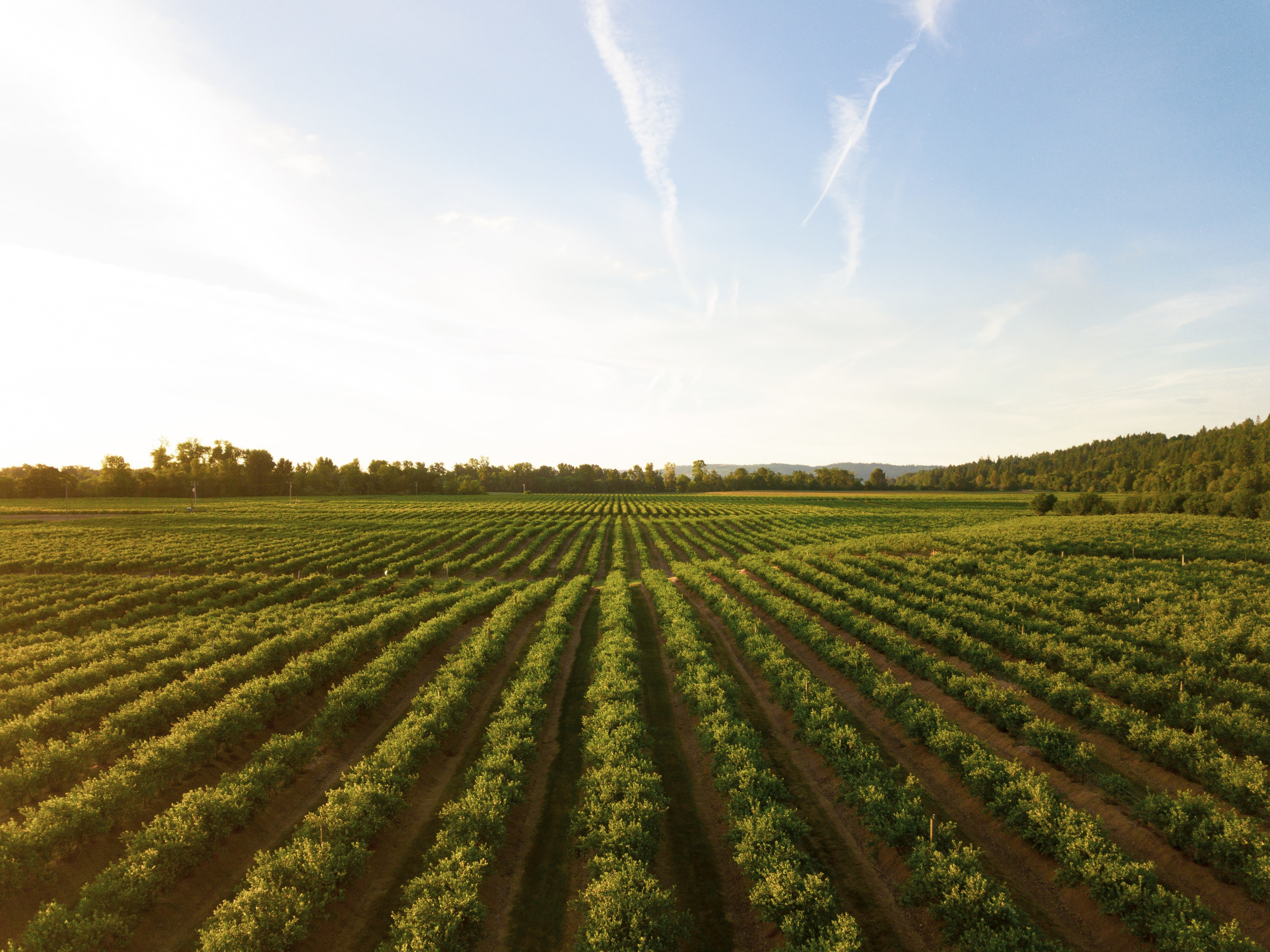
Bayer Crop Science uses Google Cloud to analyze billions of acres of land to better understand the characteristics of the soil that produces our food crops. Bayer’s teams of data scientists are leveraging services from across  Google Cloud to load, store, analyze, and visualize geospatial data to develop unique business insights. And because much of this important work is done using publicly-available data, you can too!

Agencies such as the United States Geological Survey (USGS), National Oceanic and Atmospheric Administration (NOAA), and the National Weather Service (NWS) perform measurements of the earth’s surface and atmosphere on a vast scale, and make this data available to the public. But it is up to the public to turn this data into insights and information. In this post, we’ll walk you through some ways that Google Cloud services such as BigQuery and Dataflow make it easy for anyone to analyze earth observation data at scale.


Partner with aster.cloud
for your next big idea.
Let us know here.


From our partners:

CITI.IO :: Business. Institutions. Society. Global Political Economy.
CYBERPOGO.COM :: For the Arts, Sciences, and Technology.
DADAHACKS.COM :: Parenting For The Rest Of Us.
ZEDISTA.COM :: Entertainment. Sports. Culture. Escape.
TAKUMAKU.COM :: For The Hearth And Home.
ASTER.CLOUD :: From The Cloud And Beyond.
LIWAIWAI.COM :: Intelligence, Inside and Outside.
GLOBALCLOUDPLATFORMS.COM :: For The World's Computing Needs.
FIREGULAMAN.COM :: For The Fire In The Belly Of The Coder.
ASTERCASTER.COM :: Supra Astra. Beyond The Stars.
BARTDAY.COM :: Prosperity For Everyone.

Bringing data together

First, let’s look at some of the datasets we have available. For this project, the Bayer team was very interested in one dataset in particular from ISRIC, a custodian of global soil information. ISRIC maps the spatial distribution of soil properties across the globe, and collects soil measurements such as pH, organic matter content, nitrogen levels, and much more. These measurements are encoded into “raster” files, which are large images where each pixel represents a location on the earth, and the “color” of the pixel represents the measured value at that location. You can think of each raster as a layer, which typically corresponds to a table in a database. Many earth observation datasets are made available as rasters, and they are excellent for storage of gridded data such as point measurements, but it can be difficult to understand spatial relationships between different areas of a raster, and between multiple raster tiles and layers.

Read More  Georgia Public Library Service Improves Staff And Patron Experience With ChromeOS

Processing data into insights

To help with this, Bayer used Dataflow with geobeam to do the heavy-lifting of converting the rasters into vector data by turning them into polygons, reprojecting them to the WGS 84 coordinate system used by BigQuery, and generating h3 indexes to help us connect the dots — literally. Polygonization in particular is a very complex operation and its difficulty scales exponentially with file size, but Dataflow is able to divide and conquer by splitting large raster files into smaller blocks and processing them in parallel at massive scale. You can process any amount of data this way, at a scale and speed that is not possible on any single machine using traditional GIS tools. What’s best is that this is all done on the fly with minimal custom programming. Once the raster data is polygonized, reprojected, and fully discombobulated, the vector data is written directly to BigQuery tables from Dataflow.


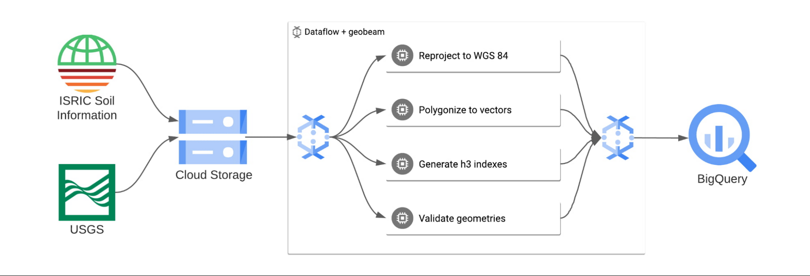
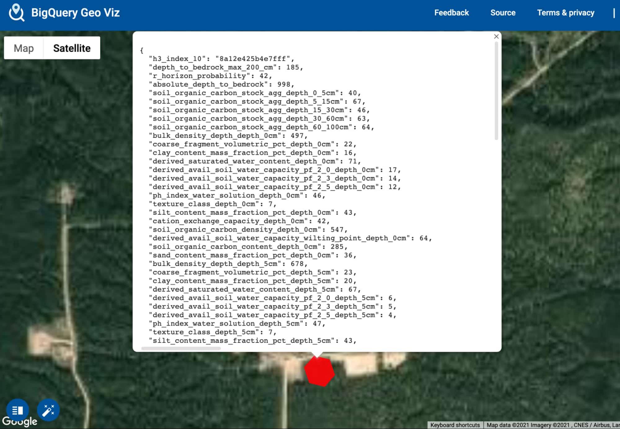
Once the data is loaded into BigQuery, Bayer uses BigQuery GIS and the h3 indexes computed by geobeam to join the data across multiple tables and create a single view of all of their soil layers. From this single view, Bayer can analyze the combined data, visualize all the layers at once using BigQuery GeoViz, and apply machine learning models to look for patterns that humans might not see

Screenshot of Bayer’s soil analysis in GeoViz


Using geospatial insights to improve the business

The soil grid data is essential to help characterize the soil characteristics of the crop growth environments experienced by Bayer’s customers. Bayer can compute soil environmental scenarios for global crop lands to better understand what their customers experience in order to aid in testing network optimization, product characterization, and precision product design. It also impacts Bayer’s real-world objectives by enabling them to characterize the soil properties of their internal testing network fields to help establish a global testing network and enable environmental similarity calculations and historical modeling.

Read More  How Google Cloud And Trigo Are Partnering To Power Autonomous Stores

It’s easy to see why developing spatial insights for planting crops is game-changing for Bayer Crop Sciences, and these same strategies and tools can be used across a variety of industries and businesses.

Google’s mission is to organize the world’s information and make it universally accessible and useful, and we’re excited to work with customers like Bayer Crop Sciences who want to harness their data to build products that are beneficial to their customers and the environment. To get started building amazing geospatial applications for your business, check out our reference guide to learn more about geospatial capabilities in Google Cloud, and open BigQuery in the Google Cloud console to get started using BigQuery and geobeam for your geospatial workloads.


By: Aswin Ramakrishnan (Sr. Data Engineer at Bayer Crop Science) and Travis Webb (Solutions Architect)
Source: Google Cloud Blog


For enquiries, product placements, sponsorships, and collaborations, connect with us at [email protected]. We'd love to hear from you!

Our humans need coffee too! Your support is highly appreciated, thank you!

aster.cloud

Related Topics
  • Agriculture
  • Bayer Crop Science
  • BigQuery GeoViz
  • BigQuery;
  • Geobeam
  • Google Cloud
You May Also Like
View Post
  • Computing
  • Multi-Cloud
  • Technology

How to create an AWS free tier account

  • July 10, 2025
View Post
  • Computing
  • Multi-Cloud
  • Technology

How to configure multiple AWS CLI authentication credentials

  • July 10, 2025
View Post
  • Technology

Formula E accelerates its work with Google Cloud Storage and Google Workspace

  • July 9, 2025
View Post
  • Computing
  • Multi-Cloud
  • Technology

What is database as a service (DBaaS)?

  • July 7, 2025
View Post
  • Computing
  • Multi-Cloud
  • Technology

The cloud’s role in PQC migration

  • July 7, 2025
View Post
  • Computing
  • Multi-Cloud
  • Technology

Hybrid cloud has hit the mainstream – but firms are still confused about costs

  • July 7, 2025
View Post
  • Technology

Building secure, scalable AI in the cloud with Microsoft Azure

  • July 5, 2025
View Post
  • Computing
  • Multi-Cloud
  • Technology

Turns out OpenAI is the customer behind Oracle’s mysterious $30 billion cloud deal

  • July 3, 2025

Stay Connected!
LATEST
  • How to create an AWS free tier account
    • July 10, 2025
  • How to configure multiple AWS CLI authentication credentials
    • July 10, 2025
  • 3
    Formula E accelerates its work with Google Cloud Storage and Google Workspace
    • July 9, 2025
  • What is database as a service (DBaaS)?
    • July 7, 2025
  • The cloud’s role in PQC migration
    • July 7, 2025
  • 6
    Hybrid cloud has hit the mainstream – but firms are still confused about costs
    • July 7, 2025
  • 7
    Building secure, scalable AI in the cloud with Microsoft Azure
    • July 5, 2025
  • 8
    Turns out OpenAI is the customer behind Oracle’s mysterious $30 billion cloud deal
    • July 3, 2025
  • aster-cloud-erp-bill_of_materials_2 9
    What is an SBOM (software bill of materials)?
    • July 2, 2025
  • aster-cloud-sms-pexels-tim-samuel-6697306 10
    Send SMS texts with Amazon’s SNS simple notification service
    • July 1, 2025
about
Hello World!

We are aster.cloud. We’re created by programmers for programmers.

Our site aims to provide guides, programming tips, reviews, and interesting materials for tech people and those who want to learn in general.

We would like to hear from you.

If you have any feedback, enquiries, or sponsorship request, kindly reach out to us at:

[email protected]
Most Popular
  • 1
    A looming hyperscaler exodus? UK IT leaders are thinking of ditching US cloud providers – here’s why
    • June 26, 2025
  • Genome 2
    AlphaGenome: AI for better understanding the genome
    • June 25, 2025
  • aster-cloud-website-pexels-goumbik-574069 3
    Host a static website on AWS with Amazon S3 and Route 53
    • June 27, 2025
  • Camping 4
    The Summer Adventures : Camping Essentials
    • June 27, 2025
  • 6 edge monitoring best practices in the cloud
    • June 25, 2025
  • /
  • Technology
  • Tools
  • About
  • Contact Us

Input your search keywords and press Enter.